Black Rock Hot Springs
- Free
- 3 hr 23 min from Albuquerque
- Roadside
A small group of springs bubbling up along the Rio Grande in the gorge north of Taos, captured into one soaking pool whose depth changes with the river level. State tourism describes it as well known, easy to reach and often busy, and reached by a short walk downstream from parking across the John Dunn Bridge.
Access rules not confirmed with BLM's Taos Field Office; check before going.
- Price
- Free
- Nearest town
- Arroyo Hondo
- From Albuquerque
- 3 hr 23 min
- Hike (one way)
- Roadside
Plan your visit
Hours & season
| Season |
|
|---|
Tickets & booking
| Price | Free |
|---|---|
| Access | Free public access |
On site
| Pools | 1 |
|---|---|
| Lodging | No |
| Land manager | BLM |
Not stated by the land manager: swimwear, ages, dogs.
Soak responsibly
- Pack out everything, including food scraps and toilet paper. Use WAG bags where required.
- No soap, shampoo or sunscreen in the pools; rinse away from the water.
- Check permits and closures with BLM before you go.
- Keep groups small and give others space. Respect posted dog and camping rules.
Water temperature
This venue doesn't publish pool temperatures.
Mineral profile
Total dissolved minerals
559 mg/L
Moderately mineralized · Sodium–sulfate (sodium sulfate water)
- pH
- 8
- Temp at source
- 99°F
- Lithium
- 0.27 mg/L
- Fluoride
- 2.9 mg/L
- Boron
- 0.25 mg/L
Lab analysis of the source water at “27n.12e.31.311 Warm Spring”, sampled 1976 by the USGS and partners (data). Pool water may be cooled, mixed or treated, and spring chemistry is generally stable over decades. We report measurements only; we don't make health claims.
What's here
- Rio Grande Gorge
- riverside pool
- depth varies with river level
- near John Dunn Bridge
- often busy
Getting there
- From Albuquerque3 hr 23 min143 mi
- From Taos40 min24 mi
- From Santa Fe (SAF)2 hr 28 min91 mi
Typical driving time without traffic or snow.
| Elevation | 6,471 ft |
|---|---|
| Road |
|
| Trail | Short walk downstream from the parking area on the west side of the river |
Things to do near Arroyo Hondo
Taos Pueblo
Multi-storied adobe pueblo north of Taos; a UNESCO World Heritage Site open to visitors on set days.
Rio Grande del Norte National Monument
BLM monument along the Rio Grande Gorge with trails and river access.
Campgrounds
- Cebolla Mesa7.7 mi
- La Junta Lower8.6 mi
- La Junta8.9 mi
- Lower Hondo9.1 mi
Trailheads
- San Christobal Canyon Trailhead8.2 mi
- Lama Canyon Trailhead10.5 mi
- Upper Slide Trail12.5 mi
- Italianos Canyon12.6 mi
Straight-line distances. Campground and trailhead data © OpenStreetMap contributors.
Nearby springs
Manby Hot Springs
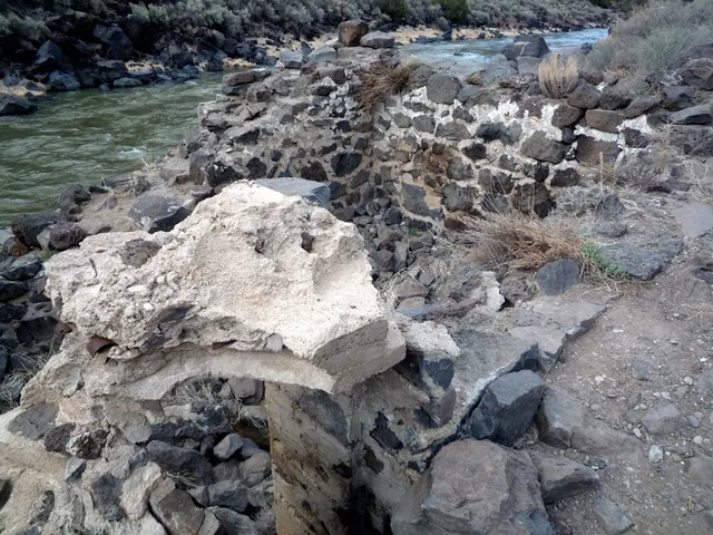
Two hot pools beside the Rio Grande at the stone ruins of an old stagecoach stop, southwest of Arroyo Hondo near Taos. State tourism describes an easy hike from the John Dunn Bridge, following the river south to the rocks that mark the pools.
Ojo Caliente Mineral Springs Resort & Spa
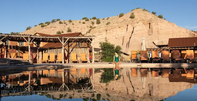
A historic spring resort below mesa cliffs on the Rio Ojo Caliente, with nine communal mineral pools named for their iron, soda, lithia and arsenic content, running about 80-105°F. Day passes are sold at the door with no reservations, and the springs are for ages 13 and up. The property also has a spa, a restaurant and wine bar, a 1916 hotel, cottages and an RV and tent campground.
Montezuma Hot Springs
Natural springs that flow from a hillside into a row of rock and cement soaking tubs of varying temperatures beside NM 65, six miles northwest of Las Vegas. They were once part of the Montezuma Castle resort and sit near the United World College campus, which is otherwise closed to the public. State tourism calls them family-friendly since no hike is needed.
Manby Hot Springs: 2 mi · Ojo Caliente Mineral Springs Resort & Spa: 25 mi · Montezuma Hot Springs: 65 mi
Sources (4)
· checked November 2026
Prices, hours and rules are checked against the official site and land-agency pages. Spot something out of date? Let us know.